 |
NAVAIDS: |
| Type: | ID: | Freq: | Radial: | Distance: |
| VOR | LBF | 117.4 | 19 deg | 5.4 mi. |
| NDB | LBF | 416 | 295 deg | 6.3 mi. |
| HOURS: | 7 am to 11 pm; on req 24 |
|
| COMM FREQ: |
| Unicom - 123 |
| FSS - 122.5 |
| CTAF - 123 |
| CLNCDEL - 132.7 |
|
|
RUNWAYS/LIGHTS/OBSTRUCTIONS:
|
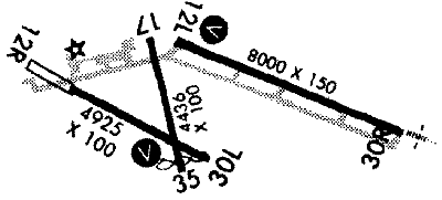
| 12L-30R 8000X150;
concrete grooved; PCL; |
| 12R-30L 4925X100;
asphalt; ; |
| 17-35 4436X100;
asphalt; PCL; road ry 17; berm ry 35 |
| APPROACHES: |
| VOR |
| GPS RNAV |
| ILS |
| NDB |
| VOR/DME RNAV |
|
| LIGHTS: |
| 24 hrs 123.00 |
Low - 3 clicks in 3 secs.
Med - 5 clicks in 5 secs.
Hi - 7 clicks in 7 secs. |
|
|
| NOTES: |
| Right tfc ry 30R & 12R |
| deer & waterfowl in vcnty |
|
| |
| WX CONTACT: |
| ASOS 118.425 308/534-1617 |
|
| NOISE ABATEMENT: |
| Maintain a min of 2,000' AGL ovr Bob Marshall Wilderness Complex, excp when apch or dep airstrip |
|
©1996-1998 Aircraft Owners and Pilots Association
Contact AOPA
|