 |
NAVAIDS: |
| Type: | ID: | Freq: | Radial: | Distance: |
| VOR | ISO | 109.6 | 233 deg | 3.8 mi. |
| NDB | ISO | 401 | 47 deg | 6.5 mi. |
|
|
| COMM FREQ: |
| Unicom - 122.95 |
| TWR - 120.6 |
| GND - 121.9 |
| FSS - 122.15 R |
| FSS - 109.6 T |
| CTAF - 120.6 |
|
|
| TRAFFIC PATTERN: |
| Light Aircraft (under 12,500 lbs) - 1100 |
| Heavy Aircraft (12,500 lbs or more) - 1600 |
| Turbine Aircraft - 1500 |
|
RUNWAYS/LIGHTS/OBSTRUCTIONS:
|
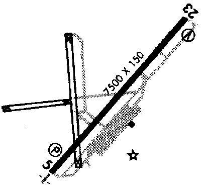
| 5-23 7500X150;
asphalt grooved; PCL; trees ea end |
| APPROACHES: |
| ILS |
| VOR |
| NDB |
| GPS RNAV |
| VOR/DME |
|
| LIGHTS: |
| 10 pm to 6:30 am 120.60 |
Low - 3 clicks in 10 secs.
Med - 5 clicks in 10 secs.
Hi - 7 clicks in 10 secs. |
|
|
| NOTES: |
|
|
|
| Intensive Flight Training |
| Commercial Airlines |
|
©1996-1998 Aircraft Owners and Pilots Association
Contact AOPA
|