 |
NAVAIDS: |
| Type: | ID: | Freq: | Radial: | Distance: |
| VOR | ILL | 113.7 | | On Field |
| HOURS: | 8 am to 5:30 pm wkdys; aft on req |
|
| COMM FREQ: |
| Unicom - 122.8 |
| FSS - 122.15 |
| CTAF - 122.8 |
|
|
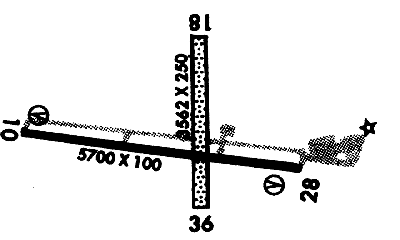
RUNWAYS/LIGHTS/OBSTRUCTIONS:
|
| 10-28 5700X100;
asphalt; PCL; trees ry 10; poles ry 28 |
| 18-36 3562X250;
turf; ; trees ry 18; pwrlines ry 36 |
| LIGHTS: |
| SS to SR 122.80 |
Low - 5 clicks in 5 secs.
Med - 5 clicks in 5 secs.
Hi - 7 clicks in 7 secs. |
|
|
©1996-1998 Aircraft Owners and Pilots Association
Contact AOPA
|