Sundance Airpark (HSD)
OKLAHOMA CITY, OK
Privately Owned, Public Use
11 mi. NW of city.
N35-36.11 W097-42.37
FBO/Facility Information
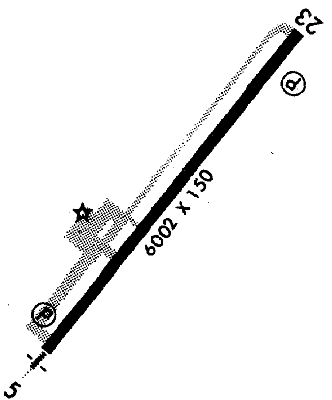
Airport Diagram
Return To Airport Directory Search
Exit Airport Directory
NAVAIDS:
Type:
ID:
Freq:
Radial:
Distance:
VOR
IRW
114.1
335 deg
15.3 mi.
MAG VAR:
7 deg E
ELEVATION:
1193 MSL
PHONE:
405/373-3886
FAX:
405/373-3893
HOURS:
8 am to 8 pm Sun thru Sat
FEES:
Tie Down Fee
CHARTS:
Dallas-Ft Worth,
L - 6
L - 13
COMM FREQ:
Unicom - 122.7
FSS - 122.65
CTAF - 122.7
CLNCDEL - 123.7
APPROACH:
Oklahoma City 124.6
TRAFFIC PATTERN:
Nonturbine Aircraft - 1990
Turbine Aircraft - 2190
RUNWAYS/LIGHTS/OBSTRUCTIONS:
17-35
5000X100; concrete; PCL;
APPROACHES:
VOR/DME RNAV
GPS RNAV
LOC
VOR
LIGHTS:
24 hrs 122.70
Low - 3 clicks in 5 secs.
Med - 5 clicks in 5 secs.
NOTES:
Right tfc ry 17
FUEL:
Not Available
FSS:
©1996-1998 Aircraft Owners and Pilots Association
Contact AOPA