 |
NAVAIDS: |
| Type: | ID: | Freq: | Radial: | Distance: |
| VOR | CHE | 115.6 | 106 deg | 4.6 mi. |
| HOURS: | daylight; aft on req |
| FEES: |
| Hangar Fee |
| Tie Down Fee |
| Parking Fee |
| Ramp Fee |
| Landing Fee |
|
|
| COMM FREQ: |
| Unicom - 123 |
| FSS - 122.1 R |
| FSS - 115.6 T |
| CTAF - 123 |
|
|
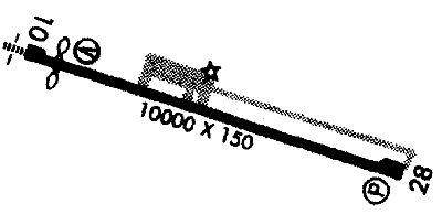
RUNWAYS/LIGHTS/OBSTRUCTIONS:
|
| 10-28 10000X150;
asphalt; PCL; pwrline ry 28 |
| LIGHTS: |
| SS to SR 123.00 |
Low - 3 clicks in 5 secs.
Med - 5 clicks in 5 secs.
Hi - 7 clicks in 5 secs. |
|
| Beacon: photo cell |
| NOTES: |
| Right tfc ry 10; acft reqd to ctc unicom 123.0 5 to 10 minutes due to plowing, prior to lndg durg winter |
|
|
| |
| WX CONTACT: |
| AWOS 119.275 970/276-3690 |
|
| NOISE ABATEMENT: |
| In efct; req all acft dep ry 28 to make right or left turnout as soon as safety pmts to avoid Hayden |
|
©1996-1998 Aircraft Owners and Pilots Association
Contact AOPA
|