Hutchinson Municipal-Butler Field (HCD)
HUTCHINSON, MN
Publicly Owned, Public Use
2 mi. S of city.
N44-51.53 W094-22.91
FBO/Facility Information
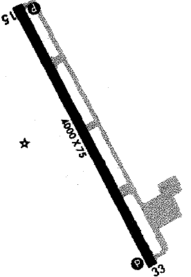
Airport Diagram
Return To Airport Directory Search
Exit Airport Directory
NAVAIDS:
Type:
ID:
Freq:
Radial:
Distance:
VOR
DWN
109
160 deg
14.1 mi.
MAG VAR:
4 deg E
ELEVATION:
1060 MSL
PHONE:
320/587-5151
FAX:
320/234-4240
HOURS:
on req
FEES:
Hangar Fee
CHARTS:
Twin Cities,
L - 10
COMM FREQ:
Unicom - 122.8
FSS - 122.2
FSS - 122
CTAF - 122.8
APPROACH:
Minneapolis Center 127.1
TRAFFIC PATTERN:
All Aircraft - 1860
RUNWAYS/LIGHTS/OBSTRUCTIONS:
15-33
4000X75; asphalt; PCL; hill ry 33
APPROACHES:
GPS RNAV
VOR/DME
NDB
LIGHTS:
24 hrs 122.80
Med - 5 clicks in 10 secs.
Hi - 7 clicks in 10 secs.
NOTES:
powerlines
Parachuting
Intensive Flight Training
FUEL:
100LL
WX CONTACT:
AWOS 118.525 320/587-3343
FSS:
©1996-1998 Aircraft Owners and Pilots Association
Contact AOPA