 |
NAVAIDS: |
| Type: | ID: | Freq: | Radial: | Distance: |
| VOR | FAR | 116.2 | 217 deg | 45.9 mi. |
|
|
| COMM FREQ: |
| FSS - 122.6 |
| FSS - 122.2 |
| CTAF - 122.7 |
|
| APPROACH: |
| Minneapolis Center 127.35 |
|
|
RUNWAYS/LIGHTS/OBSTRUCTIONS:
|
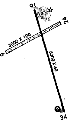
| 16-34 5000X60;
asphalt afsc; PCL; road ry 16 |
| 6-24 3000X100;
turf; ; ant ry 6; pwrline ry 24 |
| NOTES: |
| Runway 6-24 clsd winter months due to lack of snow rmvl |
|
|
| |
©1996-1998 Aircraft Owners and Pilots Association
Contact AOPA
|