 |
NAVAIDS: |
| Type: | ID: | Freq: | Radial: | Distance: |
| VOR | RBA | 112.4 | 326 deg | 15.7 mi. |
|
|
| COMM FREQ: |
| Unicom - 122.8 |
| FSS - 122.1 R |
| FSS - 112.4 T |
| CTAF - 122.8 |
|
|
RUNWAYS/LIGHTS/OBSTRUCTIONS:
|
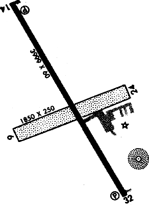
| 14-32 3999X60;
concrete; MIRL; trees ry 32 |
| 6-24 1850X250;
turf; ; trees ry 6; ant ry 24 |
| NOTES: |
| Contact FBO or APM for special req or activities |
|
|
| Ultralights |
| Aerobatics |
| Agricultural Ops |
| Ballooning |
| Helicopter Ops |
| Military Ops |
|
| Intensive Flight Training |
|
| NOISE ABATEMENT: |
| Maintain a min of 2,000' AGL ovr Bob Marshall Wilderness Complex, excp when apch or dep airstrip |
|
©1996-1998 Aircraft Owners and Pilots Association
Contact AOPA
|