 |
NAVAIDS: |
| Type: | ID: | Freq: | Radial: | Distance: |
| VOR | OTT | 113.7 | 89 deg | 32.3 mi. |
| HOURS: | 8 am to SS oct to Mar; 7 am to 7 pm Apr to Sept |
|
| COMM FREQ: |
| Unicom - 122.95 |
| FSS - 122.6 |
| CTAF - 122.95 |
| CLNCDEL - 126.9 |
|
|
| TRAFFIC PATTERN: |
| Light Aircraft (under 12,500 lbs) - 1100 |
| Heavy Aircraft (12,500 lbs or more) - 1600 |
| Turbine Aircraft - 1600 |
|
RUNWAYS/LIGHTS/OBSTRUCTIONS:
|
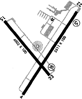
| 15-33 4002X100;
asphalt; PCL; road ry 15; trees ry 33 |
| 4-22 5511X100;
asphalt grooved; PCL; trees ry 4; road ry 22 |
| LIGHTS: |
| SS to SR 122.95 |
Med - 5 clicks in 10 secs.
Hi - 7 clicks in 10 secs. |
|
|
| NOTES: |
|
|
| Helicopter Ops |
| Military Ops |
| Ballooning |
| |
| WX CONTACT: |
| AWOS 124.475 410/822-2817 |
|
| NOISE ABATEMENT: |
| Avoid ovrflt of Easton blo 2000'; no tgls 10 pm to 7 am; dep ry 04 avoid ovrflt of trailer park 1/4 mi N of dep end |
|
©1996-1998 Aircraft Owners and Pilots Association
Contact AOPA
|