 |
NAVAIDS: |
| Type: | ID: | Freq: | Radial: | Distance: |
| VOR | CLL | 113.3 | 100 deg | 3.1 mi. |
| NDB | CLL | 260 | 341 deg | 5.9 mi. |
| FEES: |
| Hangar Fee |
| Tie Down Fee |
| Parking Fee |
| Landing Fee |
|
|
| COMM FREQ: |
| Unicom - 122.95 |
| TWR - 118.5 |
| GND - 121.7 |
| FSS - 122.65 |
| FSS - 122.2 |
| CTAF - 118.5 |
|
|
| TRAFFIC PATTERN: |
| Light Aircraft (under 12,500 lbs) - 1300 |
| Rotorcraft - 800 |
| Heavy Aircraft (12,500 lbs or more) - 1800 |
|
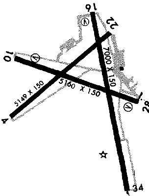
RUNWAYS/LIGHTS/OBSTRUCTIONS:
|
| 10-28 5160X150;
asphalt; MIRL; |
| 16-34 7000X150;
asphalt grooved; PCL; |
| 16-34 7000X150;
concrete grooved; PCL; |
| 4-22 5149X150;
asphalt; ; trees ry 4 |
| 4-22 5149X150;
concrete; ; trees ry 4 |
| APPROACHES: |
| NDB |
| GPS RNAV |
| ILS |
| LOC BC |
| VOR |
| VOR/DME |
| VOR(TAC) |
|
| LIGHTS: |
| SS to SR 118.50 |
Low - 3 clicks in 5 secs.
Med - 5 clicks in 5 secs.
Hi - 7 clicks in 5 secs. |
|
| Beacon: & IFR |
| NOTES: |
| E has uneven sfc; ry 4-22 day only; unsked acr opns w/more than 30 psgr seats must have 24 hr PPR; itinerant acft park S of tower; 2nd fax no. 845-5168 |
| deer in vcnty |
|
| Military Ops |
| Banner Towing |
| Helicopter Ops |
|
| Intensive Flight Training |
| Commercial Airlines |
|
| NOISE ABATEMENT: |
| Runway rstr imposed for specific acft; ctc APM |
|
©1996-1998 Aircraft Owners and Pilots Association
Contact AOPA
|