Coulter Field (CFD)
BRYAN, TX
Publicly Owned, Public Use
3 mi. NE of city.
N30-42.99 W096-19.94
FBO/Facility Information
Airport Diagram
Return To Airport Directory Search
Exit Airport Directory
NAVAIDS:
Type:
ID:
Freq:
Radial:
Distance:
VOR
CLL
113.3
26 deg
8 mi.
MAG VAR:
6 deg E
ELEVATION:
366 MSL
PHONE:
409/778-6120
FAX:
409/778-8640
HOURS:
8 am to SS
FEES:
Hangar Fee
CHARTS:
Houston,
L - 17
COMM FREQ:
Unicom - 123
FSS - 122.2
CTAF - 123
APPROACH:
Houston Center 120.4
TRAFFIC PATTERN:
All Aircraft - 1157
RUNWAYS/LIGHTS/OBSTRUCTIONS:
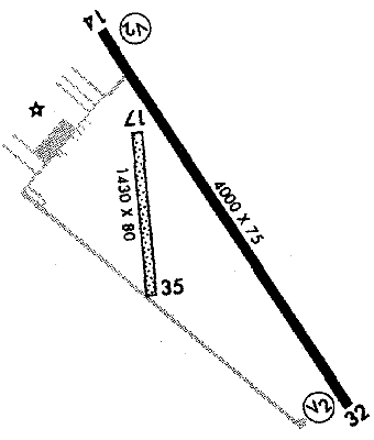
14-32
4000X75; asphalt; PCL;
17-35
1430X80; turf; ; pwrline ry 35; clsd during hvy rain
APPROACHES:
GPS RNAV
VOR/DME
LIGHTS:
123.00
Low - 3 clicks in 5 secs.
Med - 5 clicks in 5 secs.
Hi - 7 clicks in 5 secs.
NOTES:
Runway 17-35 800' of S end clsd due to ruts & drainage during wet weather
Parachuting
Soaring
Ballooning
Intensive Flight Training
Camping Facilities
FUEL:
100LL
Jet
FSS:
©1996-1998 Aircraft Owners and Pilots Association
Contact AOPA