Cram Field (BUB)
BURWELL, NE
Publicly Owned, Public Use
1 mi. SW of city.
N41-46.60 W099-8.98
FBO/Facility Information
Airport Diagram
Return To Airport Directory Search
Exit Airport Directory
NAVAIDS:
Type:
ID:
Freq:
Radial:
Distance:
VOR
OBH
114.8
294 deg
43.2 mi.
MAG VAR:
7 deg E
ELEVATION:
2181 MSL
PHONE:
308/346-4566
HOURS:
not rptd
FEES:
None
CHARTS:
Omaha,
L - 11
COMM FREQ:
FSS - 122.4
FSS - 122.2
CTAF - 122.9
APPROACH:
Denver Center 132.7
RUNWAYS/LIGHTS/OBSTRUCTIONS:
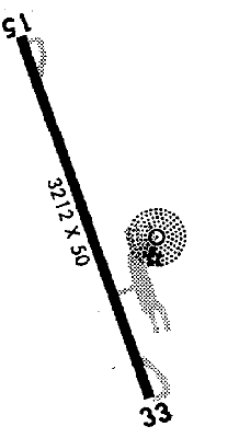
15-33
3212X50; asphalt; MIRL; trees ry 15; pwrlines ry 33
APPROACHES:
GPS RNAV
NDB
LIGHTS:
NOTES:
FUEL:
Not Available
FSS:
©1996-1998 Aircraft Owners and Pilots Association
Contact AOPA