Butler County- K W Scholter Field (BTP)
BUTLER, PA
Publicly Owned, Public Use
5 mi. SW of city.
N40-46.62 W079-56.98
FBO/Facility Information
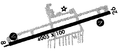
Airport Diagram
Return To Airport Directory Search
Exit Airport Directory
NAVAIDS:
Type:
ID:
Freq:
Radial:
Distance:
VOR
EWC
115.8
112 deg
12.3 mi.
MAG VAR:
8 deg W
ELEVATION:
1248 MSL
PHONE:
724/586-6665
FAX:
724/586-9644
HOURS:
6:30 am to 9:30 pm
FEES:
Hangar Fee
Tie Down Fee
Ramp Fee
CHARTS:
Detroit,
L - 23
L - 24
COMM FREQ:
Unicom - 122.8
FSS - 122.1 R
FSS - 123.6
CTAF - 122.8
CLNCDEL - 128.7
APPROACH:
Pittsburgh 124.75
TRAFFIC PATTERN:
All Aircraft - 2240
RUNWAYS/LIGHTS/OBSTRUCTIONS:
8-26
4005X100; asphalt grooved; PCL; trees ea end
APPROACHES:
ILS
GPS RNAV
LIGHTS:
SS to SR 122.80
Low - 3 clicks in 5 secs.
Med - 5 clicks in 5 secs.
Hi - 7 clicks in 5 secs.
NOTES:
Pan Am Weather Sation avbl trml bldg
FUEL:
100LL
Jet
Premix
WX CONTACT:
AWOS 133.825 724/586-6434
FSS:
NOISE ABATEMENT:
In efct; clmb ry heading to 1850' bfr turning; all times
©1996-1998 Aircraft Owners and Pilots Association
Contact AOPA