Binghamton Regional/Edwin A Link Field (BGM)
BINGHAMTON, NY
Publicly Owned, Public Use
7 mi. N of city.
N42-12.51 W075-58.78
FBO/Facility Information
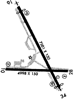
Airport Diagram
Return To Airport Directory Search
Exit Airport Directory
NAVAIDS:
Type:
ID:
Freq:
Radial:
Distance:
VOR
CFB
112.2
76 deg
7.6 mi.
NDB
BGM
332
340 deg
7.4 mi.
VOR
CFB
112.2
76 deg
7.6 mi.
MAG VAR:
12 deg W
ELEVATION:
1636 MSL
PHONE:
607/763-4471
FAX:
607/763-4475
FEES:
Landing Fee
CHARTS:
New York,
L - 25
COMM FREQ:
TWR - 119.3
GND - 121.9
FSS - 122.1 R
FSS - 112.2 T
CLNCDEL - 125.05
APPROACH:
New York Center 132.175
Binghamton 118.6
Binghamton 127.55
TRAFFIC PATTERN:
All Aircraft - 2430
RUNWAYS/LIGHTS/OBSTRUCTIONS:
10-28
4998X150; asphalt grooved; PCL;
16-34
7501X150; asphalt grooved; PCL;
APPROACHES:
ILS
VOR
NDB
GPS RNAV
VOR/DME
LIGHTS:
119.30
Low - 3 clicks in 3 secs.
Med - 5 clicks in 5 secs.
Hi - 7 clicks in 5 secs.
NOTES:
birds in vcnty
Helicopter Ops
Military Ops
Commercial Airlines
FUEL:
100LL
Jet
Premix
WX CONTACT:
ATIS 128.15
ASOS 607/729-8335
FSS:
NOISE ABATEMENT:
In efct
©1996-1998 Aircraft Owners and Pilots Association
Contact AOPA