 |
NAVAIDS: |
| Type: | ID: | Freq: | Radial: | Distance: |
| VOR | AXN | 112.8 | 224 deg | 8.8 mi. |
| NDB | AJW | 281 | 315 deg | 5.8 mi. |
| HOURS: | 8 am to 7 pm wkdays; 9 am to 5 pm wkends |
|
| COMM FREQ: |
| Unicom - 123 |
| FSS - 122.6 |
| CTAF - 123 |
|
|
| TRAFFIC PATTERN: |
| Light Aircraft (under 12,500 lbs) - 2220 |
| Heavy Aircraft (12,500 lbs or more) - 2420 |
|
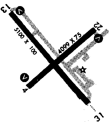
RUNWAYS/LIGHTS/OBSTRUCTIONS:
|
| 13-31 5100X100;
asphalt; PCL; |
| 4-22 4099X75;
asphalt; PCL; building ry 4; tree ry 22 |
| LIGHTS: |
| SS to SR 123.00 |
Low - 3 clicks in 5 secs.
Med - 5 clicks in 5 secs.
Hi - 7 clicks in 5 secs. |
|
|
| WX CONTACT: |
| AWOS 118.375 320/763-7174 |
|
©1996-1998 Aircraft Owners and Pilots Association
Contact AOPA
|