 |
NAVAIDS: |
| Type: | ID: | Freq: | Radial: | Distance: |
| VOR | ACY | 108.6 | 146 deg | 8 mi. |
| VOR | VCN | 115.2 | 124 deg | 26 mi. |
|
|
| COMM FREQ: |
| Unicom - 123 |
| FSS - 123.65 |
| FSS - 122.65 |
| CTAF - 123 |
| CLNCDEL - 121.7 |
|
| APPROACH: |
| Atlantic City 134.25 |
| Atlantic City 124.6 |
|
|
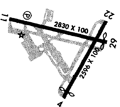
RUNWAYS/LIGHTS/OBSTRUCTIONS:
|
| 11-29 2830X100;
asphalt; MIRL; pwrlines ry 11; hotel ry 29 |
| 4-22 2596X100;
asphalt; MIRL; |
| NOTES: |
| Right tfc ry 22 & 29; ry 4 clsd for lndg, ry 22 clsd for tkof;760' MSL ry 11, 860' MSL ry 22 & 29 |
| ship masts 35' in chnl 200' all rys; poles 11; bldg 29 |
|
| Ultralights |
| Helicopter Ops |
| |
| NOISE ABATEMENT: |
| Tower advises left turn ASAP ry 11 dep |
|
©1996-1998 Aircraft Owners and Pilots Association
Contact AOPA
|