 |
NAVAIDS: |
| Type: | ID: | Freq: | Radial: | Distance: |
| VOR | BTG | 116.6 | 257 deg | 11.5 mi. |
|
|
| COMM FREQ: |
| Unicom - 122.8 |
| FSS - 122.3 |
| CTAF - 122.8 |
| CLNCDEL - 121.65 |
|
|
| TRAFFIC PATTERN: |
| Light Aircraft (under 12,500 lbs) - 1000 |
| Rotorcraft - 500 |
|
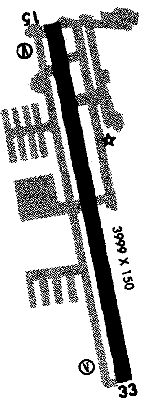
RUNWAYS/LIGHTS/OBSTRUCTIONS:
|
| 15-33 4000X150;
asphalt rfsc; MIRL; tree ry 33 |
| NOTES: |
| Right tfc ry 33; calm wind ry 15; ASOS 135.875 rptd |
|
|
| Military Ops |
| Ultralights |
| Soaring |
| Agricultural Ops |
| Gyrocopters |
| Helicopter Ops |
|
| Intensive Flight Training |
| Camping Facilities |
|
©1996-1998 Aircraft Owners and Pilots Association
Contact AOPA
|